Best Handbook of Geospatial Artificial Intelligence: GEOAI

Geospatial Artificial Intelligence (GEO:AI) is a newly established scientific field that merges spatial science with advancements in artificial intelligence (AI), including machine learning, data mining, and high-performance computing. It aims to extract valuable insights from large-scale spatial data sets, also known as spatial big data.
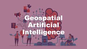
What is Geospatial Artificial Intelligence
Geospatial Artificial Intelligence (GeoAI) combines artificial intelligence with geospatial data, science, and technology to enhance understanding of business opportunities, environmental impacts, and operational risks. It involves automating data generation and using spatial tools and algorithms to enable organizations to modernize their operations and scale efficiently.
By leveraging your existing expertise in medical geography, global health, GIScience, extreme events and hazards, earth systems science, sustainability, and global change, and expanding into AI and atmospheric sciences, you can tackle a wide range of challenges. This approach allows you to provide valuable insights and solutions while training a skilled workforce in the rapidly evolving field of GEO AI. It’s an exciting endeavor that has the potential to make a significant impact on understanding and addressing complex geographical and societal issues.
Geospatial Artificial Intelligence Aims
Geospatial AI aims to extract meaningful insights, patterns, and relationships from large and complex geospatial data sets. This data can include information such as satellite imagery, aerial photographs, GPS data, maps, and other spatially referenced data sources. By leveraging AI algorithms, geospatial AI systems can automate the analysis of these data sets, identify patterns, make predictions, and provide valuable information for various applications.
The integration of AI techniques with geospatial data analysis enables the discovery of hidden patterns, the prediction of spatial phenomena, and the development of intelligent systems for tasks such as land-use classification, object detection and recognition, urban planning, environmental monitoring, disaster management, transportation optimization, and more. Geospatial AI has the potential to revolutionize how we understand, manage, and utilize spatial data for a wide range of applications across various industries.
Geospatial Artificial Intelligence Benefits
GeoAI offers several benefits to improve data quality, consistency, and accuracy. By leveraging automation, manual data generation workflows can be streamlined, increasing efficiency and reducing costs.
Furthermore, GeoAI enables accelerated situational awareness by monitoring and analyzing events, assets, and entities from various sources, such as sensors and video feeds. This allows for quicker response times and proactive decision-making.
Additionally, GeoAI brings location intelligence to decision-making processes, empowering organizations to make data-driven decisions in real-world contexts. By incorporating spatial patterns and accurate predictions, businesses can improve outcomes and achieve better results.
GeoAI
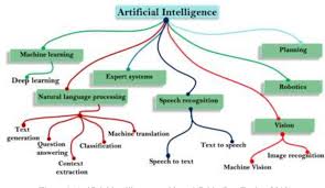
GeoAI is gaining prominence in the geospatial community as it combines spatial science innovations with advancements in AI and big data. It encompasses three pillars: data-driven approaches, knowledge-driven methodologies, and a focus on geospatial applications.
In terms of knowledge, GeoAI emphasizes machine learning, deep learning, data mining, and high-performance computing to extract meaningful insights from spatial big data. Regarding big data, scalable and distributed processing techniques and intelligent analysis are key considerations in GeoAI.
GeoAI is an interdisciplinary field, connecting disciplines such as geography, geosciences, computer science, and engineering. Its flexibility allows for the application of GeoAI in addressing real-world problems. It serves as an emerging spatial analytical framework for data-intensive Geographic Information Science, accommodating both large and small datasets within a broader context.
Why is GeoAI important?
GeoAI is revolutionizing our ability to extract insights from complex datasets, enabling us to tackle the most critical challenges facing our planet. By uncovering intricate patterns and relationships in rapidly expanding data, it empowers organizations to transform data into actionable information. GeoAI models are designed to adapt and evolve as data continues to grow, facilitating more effective decision-making and problem-solving.
How is GeoAI used?
GeoAI is widely applied across industries to address challenges and capitalize on opportunities through proactive decision-making.
- State and local government
- Natural resources
- National mapping and statistics
- Defense and intelligence
- Public safety
- Insurance
- AEC
GeoAI plays a crucial role in accelerating the extraction of information, pattern identification, and change detection in large-scale datasets. It enables intelligence organizations to automate the analysis of event-related information, entities, surveillance videos, and remotely sensed data, supporting their activity-based intelligence efforts.
Geospatial Artificial Intelligence and Spatial Computing
Spatial computing enables us to move away from traditional input devices like keyboards and screens by overlaying digital information onto our physical environment using devices like headsets or glasses. In contrast, multimodal AI comprehends the world through various modes of input such as images, text, sound, and more, similar to human perception.
Spatial computing is indeed an intriguing concept that drives technological innovation by integrating various computing environments. It facilitates the seamless integration of observation, computer-aided design, and decision-making processes. Unlike the current capabilities of virtual and augmented reality, spatial computing enables the integration of information collected from diverse sources and scales. Its applications span from indoor mapping to outdoor mapping, providing overviews of neighborhoods and urban areas. Moreover, spatial computing has the potential to integrate with domains such as vegetation, disaster management, agriculture, health, and water-oriented studies.
Handbook of Geospatial Artificial Intelligence
The Handbook of Geospatial Artificial Intelligence provides a comprehensive overview of the integration of geospatial studies with AI machine learning, deep learning, and knowledge graph technologies. It covers fundamental concepts, methods, models, and technologies of GeoAI and explores recent advances, research tools, and applications in areas like environmental observation, social sensing, and natural disaster responses. As the first single volume on this rapidly evolving field, the handbook serves as a valuable resource for educators, students, researchers, and practitioners in information science, environment and natural resources, geosciences, and geography who utilize GeoAI in their work.
The Handbook of Geospatial Artificial Intelligence offers:
- Systematic introductions and discussions of GeoAI theory, methods, technologies, applications, and future perspectives.
- Coverage of a wide range of GeoAI applications and practical case studies.
- Supplementary materials include data sets, programming code, tools, and additional case studies.
- In-depth exploration of recent developments in GeoAI methods and tools.
- Contributions from top experts in the field, providing insights into cutting-edge GeoAI topics.
- What is Generative AI vs Predictive AI: 5 Best Key Benefits
-
Predictive AI vs Generative AI | Best Models | Tools
- How to use Janitor AI without API: Simplify Your Workflow
- Get High-Quality Leads With AI for Lead Generation Software
- How to Use AI Lead Generation Software: 5 Best Practices
- What is the Role of AI in the Digital Transformation of Education?
- 5 Best AI Music Video Generators Free and Paid
- How to Make an AI Voice Model: Tech That Transforms
- How to Make AI-Generated Video|AI video generator
- Handbook of Geospatial Artificial Intelligence